
Study using satellite data finds rate of urban growth much greater than previously thought
Green Car Congress
MAY 10, 2020
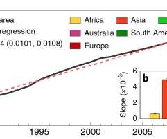
The researchers used Landsat imagery to map annual changes in urban extent at a 30 m resolution for the period 1985 to 2015 on the Google Earth Engine (GEE) platform. The expansion rates in Asia and North America substantially exceeded those of Europe (1,883 km 2 yr –1 ). —Liu et al.


Let's personalize your content