
MIT, QCRI use AI to enrich digital maps to improve GPS navigation; RoadTagger
Green Car Congress
FEBRUARY 3, 2020
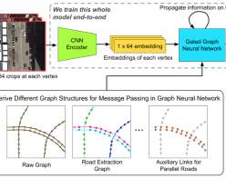
A model developed by Researchers at MIT and Qatar Computing Research Institute (QCRI) have developed a model that uses satellite imagery to tag road features in digital maps to help improve GPS navigation. Each tile is a separate graph node, connected by lines along the road. The CNN takes as input raw satellite images of target roads.


Let's personalize your content