
MIT, QCRI use AI to enrich digital maps to improve GPS navigation; RoadTagger
Green Car Congress
FEBRUARY 3, 2020
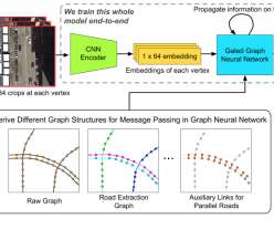
A model developed by Researchers at MIT and Qatar Computing Research Institute (QCRI) have developed a model that uses satellite imagery to tag road features in digital maps to help improve GPS navigation. Showing drivers more details about their routes can often help them navigate in unfamiliar locations.


Let's personalize your content