Connie McCreath, Operations Manager of Northern Space and Security Ltd, discusses the company’s critical role in the Space Situational Awareness industry.
Space has become a significant contributor to modern society. In the early decades of the space age, little was done for the maintenance of space, particularly for long-term sustainability. However, with the rise in both orbital congestion and a significant increase in the threat of hostile acts in space, the space industry today must actively work towards the preservation of our near-Earth environment. As the regulatory and policy environment is in its infancy, responsible acts in space are only possible through ensuring space operators are informed and conscientious of their actions.
Data coverage and understanding of the entire space domain are imperative to ensure long-term benefits from space. Space sustainability is indispensable to the current and future space industry, and active space sustainability can only be achieved through true Space Situational Awareness (SSA).
Currently, there is no singular service provider in the space industry that delivers the entire spectrum of services required to accomplish true SSA. Commercial SSA provider Northern Space and Security Limited (NORSS) plans to change this with its vision of end-to-end SSA.
What is SSA?
SSA in its simplest form is the understanding of activities in near-Earth orbit through the fusing of Space Surveillance and Tracking (SST) data, understanding the space environment (space weather), and knowledge of the commercial/geopolitical intents of operators. It is an essential and large global endeavour to preserve the safety and security of satellites in orbit. Achieved through persistent operations supported by cataloguing and tracking; it is only through this capability that monitoring and supporting operations in space are possible. SSA services are vital to space sustainability and operational risk mitigation. Surprisingly, SSA is only now increasingly being recognised as an essential discipline required to safeguard the longevity and maintenance of crucial space objects and space-based infrastructure.
The success and safety of all space users rely on accurate and timely SST supporting SSA. Government entities (both civil and military), need to maintain awareness of the space environment for security, regulatory, and sustainability reasons. Civilian requirements for SSA data often include regulation and compliance monitoring, maintaining critical national infrastructure, and upholding international regulation. Military SSA needs (often now referred to as Space Domain Awareness (SDA), although not clearly defined) can vary but typically revolve around maintaining awareness of the space environment and maintaining a tactical advantage to provide safe and secure space operations.
The commercial space industry has a vested interest in SSA data and services predominately to maintain awareness of the on-orbit region around their own satellites and to maintain the safety of flight for satellite owners and/or operators. Academia is largely focused on advancing the R&D areas of SSA and has an interest in maintaining the long-term sustainability of outer space.
End-to-end SSA/SST chain
Achieving global SSA is a complex task that requires the integration of hardware, software, and human input. The full end-to-end SSA process can be broken down into three discrete stages: data acquisition, data processing, and data analysis. Each stage is equally as valuable and each demand high accuracy and further refinement through investment from the wider space industry.
Data acquisition
Traditionally, acquiring the sensor hardware capable of gathering raw space observation data has been an expensive endeavour, with limited financial return. Therefore, purchasing observation data from dedicated SSA sensor providers is often just as costly. Conventional radar technologies employed to track and monitor our increasingly most congested orbital regime, low Earth orbit (LEO), require a vast financial investment. Modest space observation radars are valued at a few tens of millions of pounds. More advanced radar systems can demand investment at an order of magnitude greater. For example, in 2014, the U.S. Air Force awarded American aerospace company Lockheed Martin a £546m contract to develop the ground-based radar system known today as ‘Space Fence’.1
Although Space Fence is highly adaptable – capable of tracking resident space objects (RSOs) across most orbital regimes including LEO, medium Earth orbit (MEO), and geostationary Earth orbit (GEO) – this costly sensor is not without its limitations. The most significant limitation being Space Fence’s narrow field of view. Other sensor technologies, such as advanced optical telescopes employed to observe GEO, are not far behind radar, traditionally demanding significant investment for quality data returns.
Data processing
Following the acquisition of raw space data, the data must be processed to be both machine- and human-readable. It is only through the ability to process raw space observation data that we can add value to it and begin to map the space environment to achieve successful space sustainability. Data processing incorporates the raw observed data with the numerical properties of the sensor in question. This data is then fed through mathematical models and algorithms, generating readable data regarding the observed objects’ orbital properties and other physical characteristics.
Open-sourced processed tracking data is available through the US Space Surveillance Network (SSN). The SSN is the largest and most comprehensive network of radars and optical telescopes and publishes the most comprehensive catalogue of objects. This freely available catalogue is used almost exclusively by all space-faring nations and satellite owners/operators in some way.
Although extremely useful, this centralised data source has limited supporting information. For example, the quality and accuracy of the processed tracking data depend on supporting information including US sensor calibration data, the mathematical models used by the US military, and the uncertainties applied to said models to generate the outputs – released as two-line elements (TLEs). This information is sensitive and will never be fully openly shared by the US with the rest of the space community. Therefore, to have confidence in the fidelity and quality of processed observation data, raw data processing should be done in-house, in a transparent environment where all data sets and processes can be shared freely.
LEO Optical Camera Installation – LOCI
The economic burden traditional SSA data acquisition and processing places on all space players to monitor their assets on-orbit is significant and undeniable. Historically performed by the US military, there is now a greater need for this to be passed to civil organisations. The risk of damaging one’s spacecraft on-orbit, due to direct impact with another RSO, was historically low as the number of objects distributed across the orbits was significantly lower. Two years ago, there were only around 1,700 active satellites and now there are more than 5,000. Monitoring satellite safety was seen as of lower importance and priority. Often, satellite operators would invest little to no money in tracking their satellites in an effort to keep them safe.
However, with the growing frequency of launches, rise of LEO constellations, and exponential increase in debris – thanks to an ageing RSO population and abundant subsequent fragmentation from kinetic anti-satellite (ASAT) missile tests – operators can no longer assume space is a safe environment.
Additionally, the value and need for space sustainability is increasingly being recognised as a responsibility of all who operate and benefit from space. So how can the SSA industry address this issue? How can the SSA market become more accessible to all? The answer is low-cost, high-accuracy SSA sensors. NORSS has now developed such technologies.
NORSS’ LEO Optical Camera Installation (LOCI) is a bespoke SST sensor based on simulation-driven design and commercial off-the-shelf hardware, resulting in low-cost, reliable, and effective surveillance data to support SSA. The LOCI system has been designed, built, and tested from the ground up with the needs of the ever-evolving SSA market in mind. Utilising in-house optical system simulation software to find the most favourable system characteristics, NORSS can produce a novel system tailored to tackle the challenges of LEO optical observation.
As well as LEO, LOCI can also be tailored to catalogue and characterise objects in MEO and GEO. With long-term expectations to house multiple systems in intelligent locations around the globe, this affordable technology is likely to change the face of the SSA/SST market as we know it.
Data analysis
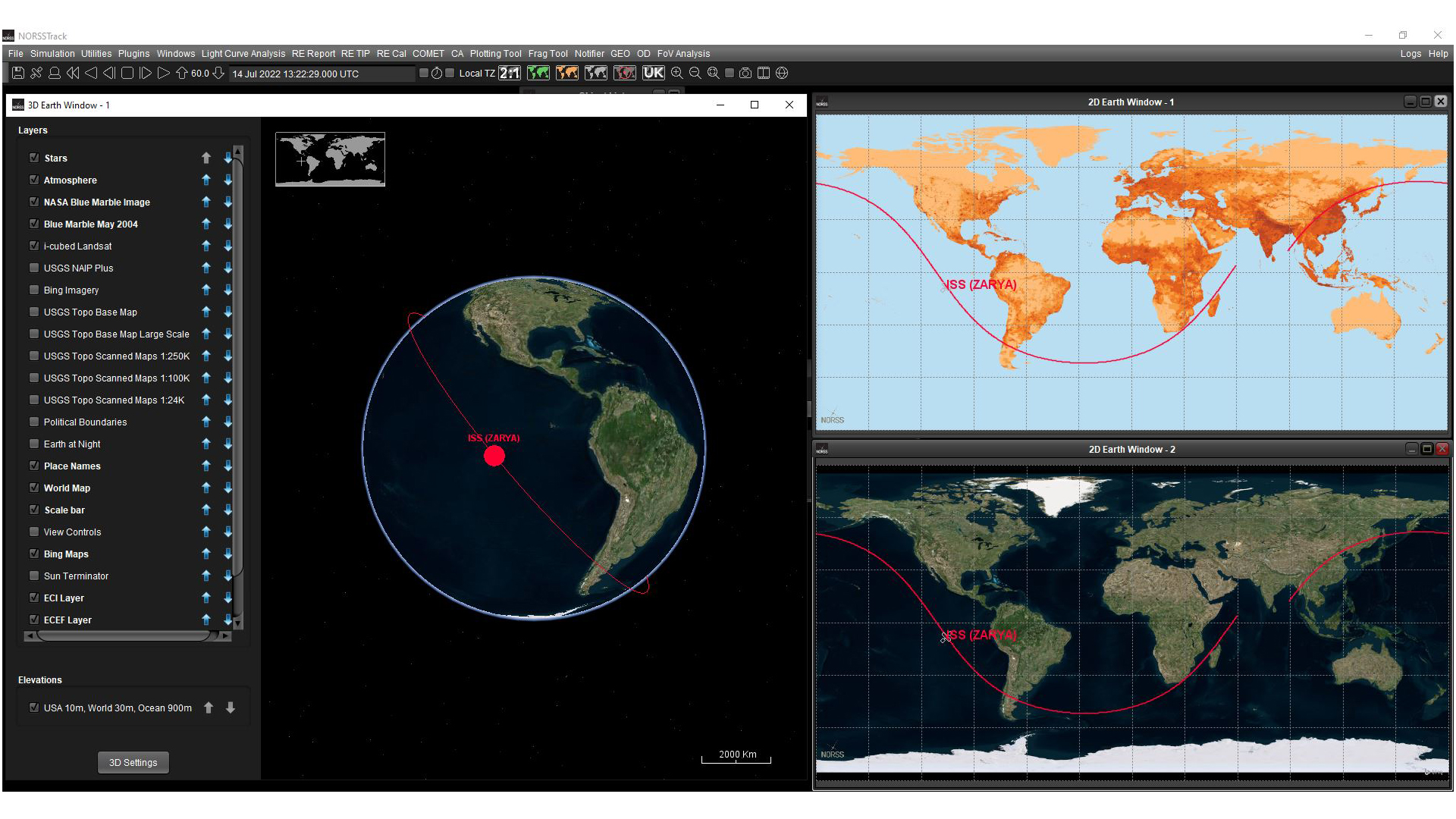
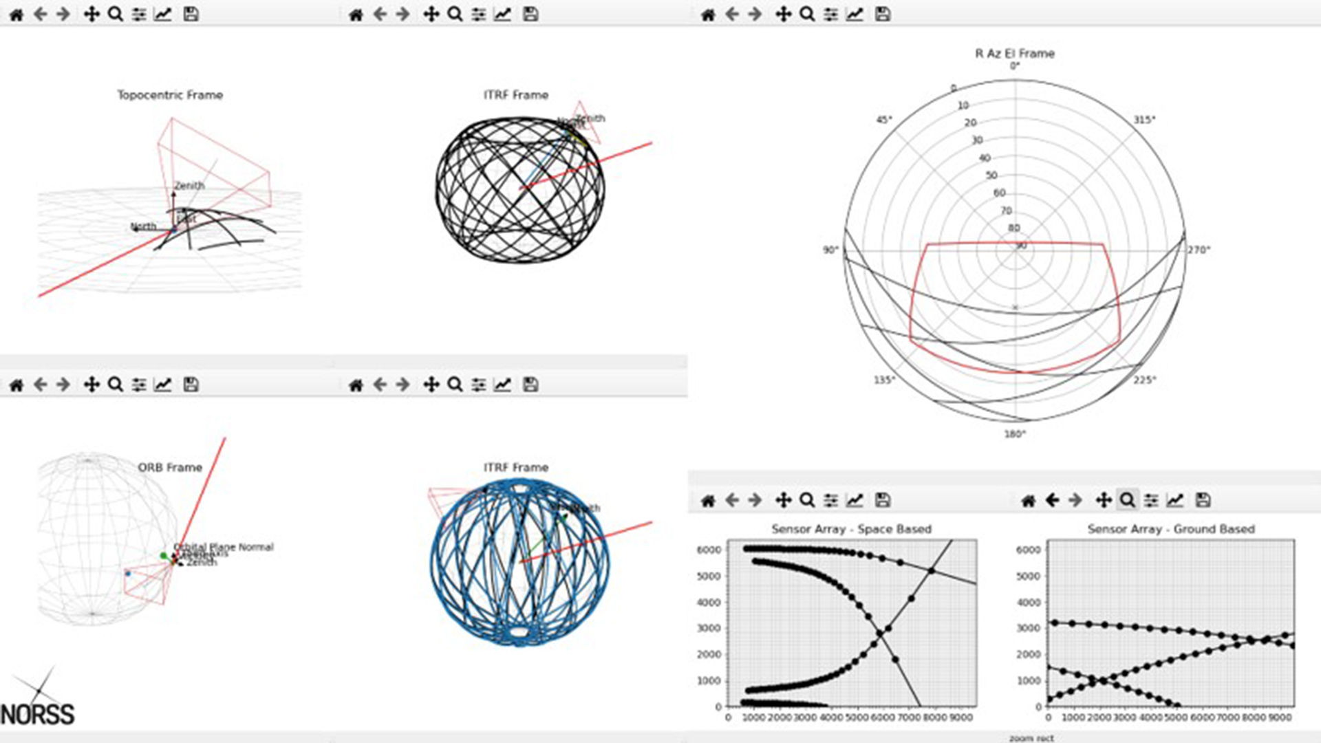
The final stage in the SSA end-to-end chain is analysing the processed data. This analysis requires bespoke SSA software designed to complement the skillset of an orbital analyst. Currently, NORSS is one of the only commercial providers in the UK to deliver orbital analytics and SSA products to the UK government. Additionally, through their Orbital Analyst Operations Centre, the Hive, NORSS is developing the expertise critical to support the space industry and enhance space sustainability. The NORSS Hive works with national and international partners, enhancing research in the field of SSA/SST and space operations.
NORSS has developed bespoke SSA/SST software, created to meet both the specific requirements for supporting Hive orbital analysis and the broader space community. These SSA/SST software packages enable the in-depth analysis of on-orbit events for thorough investigation, high-quality outputs, and visualisation of events as required. High-accuracy sensor operations are achieved through internally developed object acquisition and tasking modules, while space traffic management is supported in the Hive by means of modelling technical orbital risk assessment.
The need for specialist SSA software capabilities is indisputable. Key space events must be analysed, not only to achieve space sustainability, but also to maintain current technologies on-orbit and maximise their efficiency and usability on the ground. NORSS ensures in-flight safety through satellite manoeuvre detection and compliance monitoring of UK-registered space objects and the greater global space population. Monitoring such events is imperative for both asset safety and national security. Additionally, the Hive monitors newly-launched objects as they approach operational orbits to maintain general situational awareness of both spacecraft and the space environment.
Other crucial space events that are of high priority when ensuring space flight safety and space sustainability include satellite re-entries, conjunction and collision assessment, and fragmentation events. Re-entry analysis, for example, involves forecasting objects nearing end-of-life that are on track to re-enter Earth’s atmosphere. It is important to understand the range of possible re-entry locations and times. These statistics indicate the likelihood of re-entry over the UK, UK Overseas Territories, or partner nations, and the distribution of population densities over the locations at risk of impact.
Continuing successful sustainability
The success and future of the space industry cannot exist without the active pursuit of global SSA. Without SSA, pioneering space technologies such as Active Debris Removal (ADR), Rendezvous Proximity Operations (RPOs), Mission Extension Vehicles (MEVs), and all related satellite security and maintenance missions would not be possible. While research and innovation in the SSA/SST market is in its infancy, new ground-based and space-based SSA technologies are slowly emerging.
NORSS plays a critical role in the SSA/SST industry delivering high-accuracy, high-quality, and low-cost SSA services. Together, through global collaboration and innovation, sustainable success from outer space can become a reality.
References
About NORSS
Founded in 2017, Northern Space and Security Limited (NORSS) is the only UK-based commercial company dedicated to SSA/SDA/SST and developing Orbital Analytics. An innovative company located across the northeast of England, its mission is to empower success through opportunities in outer space, supporting industry and academic use of space, and helping governments to regulate space through unprecedented access to data of space. The company’s expertise results from a highly skilled team of people along with several key personnel bringing more than 100 years of combined experience in SST/SSA, across military and civilian sectors.
NORSS operates its Orbital Analyst Hive, an SSA/SDA centre of excellence, to ensure the long-term development of operational experience to meet sustainable orbital challenges. Investing in both the technical capability and developing highly qualified personnel is fundamental to the UK’s only commercial analytical SSA cell. The significant experience of the team is built upon strong relationships between NORSS and key national and international partners. Its links across industry, academia, and government, both the civilian and military realms, enable the acquisition of vital data and information which adds significant depth to services provided and supports rapid development of experience.
Furthermore, NORSS also has extensive access to Space Policy and Law experience through its collaboration with Professor Chris Newman, Professor of Space Law and Policy at Northumbria University, including the ground-breaking Space Law Games; an innovative three-year project to view significant developments in space operations through the Space Law lens, highlighting future technical requirements for space traffic management.
Please note, this article will also appear in the eleventh edition of our quarterly publication.