Australia, Canada, & US Unify Critical Minerals Data
The U.S. Geological Survey (USGS) has released a compilation of national-scale geological, geophysical and mineral resource datasets from Australia, Canada and the US through a collaboration between the three countries’ federal geological surveys.
“Geology doesn’t stop at the border and neither does our data,” said USGS scientist Anne McCafferty, who led the effort. “Scientists will now be able to look at geological and geophysical data seamlessly across both Canada and the United States, as well as make direct comparisons to Australia.”
“This joint data release speaks to our continued commitment to improve scientific cooperation and data sharing between the U.S. Geological Survey, Geoscience Australia, and the Geological Survey of Canada,” said Geological Survey of Canada scientist Christopher Lawley.
“These standardized datasets, spanning the continents of Australia and North America, enable unique investigations into the controls on critical mineral distribution which were simply not possible beforehand,” said Geoscience Australia scientist Karol Czarnota. “I’m sure they will be a foundation for ongoing research and innovation for many years to come.”

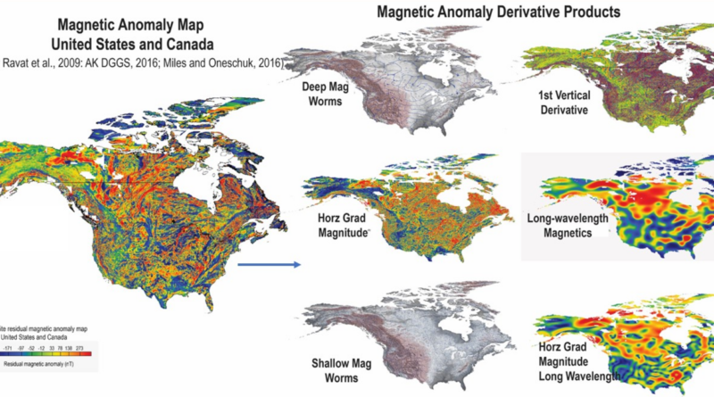
The data release includes more than 40 earth science data layers, including a new map of variations in the Earth’s natural magnetic field for the entirety of Canada and the United States that scientists can use to develop three-dimensional representations of geology underground. The data layers are in widely accepted geographic information system formats.
The data release was prepared by the Geological Survey of Canada, Geoscience Australia and the USGS as part of the Critical Minerals Mapping Initiative (CMMI). The CMMI combines the three geological surveys’ expertise to develop a better understanding of known critical mineral resources, determine geologic controls on the distribution of deposits from which critical minerals are currently being produced, identify new sources of supply through critical mineral potential mapping and quantitative mineral assessments, and promote critical mineral research in all three countries.

These data will also be useful to inform assessments of the three nations’ natural hazards, such as earthquakes and landslides, and other natural resources such as geothermal energy and groundwater. The data are seamless across the United States and Canada and can easily be compared with data from Australia.
In addition, the data layers can be used for artificial intelligence analytical techniques, such as machine learning. For example, a CMMI team led by the Geological Survey of Canada has already used the data layers to map the potential in Australia, Canada and the United States for certain types of zinc deposits which, in addition to zinc, are also known to contain other critical minerals such as germanium and gallium. The international team of scientists is now extending their efforts to model potential for other critical mineral systems.

This data release, and CMMI more generally, are part of a broad effort between Australia, Canada and the United States to collaborate on diversifying supply lines for critical mineral resources, secure trade of those resources, and ensure availability of the resources for each country’s economy and security. The effort includes agreements that establish effective coordination between the three countries as well as scientific partnerships to provide a data-driven foundation.
The data layers can be accessed here. More information about the CMMI can be accessed here. More information on critical minerals research at the Geological Survey of Canada can be found here. More information on critical minerals research at Geoscience Australia can be found here. More information on critical minerals research at the USGS can be found here. To stay up to date with critical minerals science and other activities by the three agencies, follow the Geological Survey of Canada, Geoscience Australia and the USGS on Twitter.
By U.S. Geological Survey, U.S. Department of the Interior
Have a tip for CleanTechnica? Want to advertise? Want to suggest a guest for our CleanTech Talk podcast? Contact us here.
Latest CleanTechnica.TV Video

CleanTechnica uses affiliate links. See our policy here.